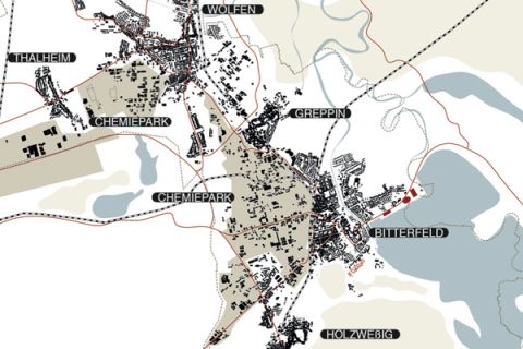
Bitterfeld Wolfen
The Bitterfeld-Wolfen region has been in transformation since the advent of industrialisation. Various phases of serial transformation have left deep marks in the landscape. Mining activities succeeded medieval agriculture. The industrial revolution altered cities and landscapes. The decline of industry again triggered a re-orientation towards new technologies, environment and recreation. Traces of the various transformation processes are legible in Bitterfeld-Wolfen region still today. These processes are not complete. Their multiplicity and simultaneity demands a participatory process of planning. These processes have become parallel processes that overwrite each other. The Bitterfeld-Wolfen region has entered a dynamic equilibrium between change, invention and rejuvenation. As a result of the discontinuity of historical patterns of development the Bitterfeld-Wolfen region is characterised by a degree of “artificiality” of the city, landscape and environment. The proposed design sees this as a quality to be embraced and to be integrated into the urban development process. Three transformation axis' become visible that have immediate impact on landscape, urbanism and architecture:
ECOLOGICAL AXIS OF TRANSFORMATION
Historic transformation processes have radically and irrevocably altered the landscape. Former industrial mining areas have been flooded, landfilled, built-up or “re-naturalised”. The Bitterfeld-Wolfen region is a mosaic made of urban areas, agricultural zones and nature-like recreational areas. Traces of human activity of the past shape the spaces inhabited by humans, animals and plants. As seen during the last floods this spring, planning needs to consider the larger scales of the environmental forces. Urbanism, landscape architecture and architecture become the agents of change to support and design ecological systems.
DEMOGRAPHIC AXIS OF TRANSFORMATION
The changing living circumstances of the inhabitants of the Bitterfeld-Wolfen region with respect to the environment, modes of production and space lead to a constant demographic change. Similar to the transformation of the landscape the process of demographic change is not linear nor closed but understood as great potential of the site. In response the design is open and flexible. Urbanism, landscape and architecture act as guiding devices, leaving certain spaces deliberately vague and open for interpretation. Landscape can act as recreational space, agricultural land or as instrument for flood-protection. Urbanism can be implemented in phases with spaces left for future expansion. The architecture is modular and flexible. The resulting combinatory possibilities create the largest possible acceptance amongst the current and future residents.
ECONOMIC AXIS OF TRANSFORMATION
The Bitterfeld-Wolfen region is in the process of re-inventing itself economically due to the ongoing ecological and demographic transformation processes. The region aims to lead in the field of service, recreation and creative industry based on its lasting tradition of technology and innovation. The potential of the region is huge if the spaces necessary can be mobilised appropriately. The design proposal delivers the a concise design by creating adequate spaces on the urban and landscape architecture level in combination with a flexible and informal architecture catering to the needs of the creative society. This results in new spatial and functional typologies that create a lasting balance of dwelling, working, culture and leisure.
ARTIFICIALITY
The planning is based on the assumption that the region of Bitterfeld-Wolfen features a particular kind of positive “artificiality“, reflected in the approach to urbanism, landscape and architecture. This “artificiality” confirms the dynamic and innovative heritage of the region and is not to be confused with alienation. In return the design is informal, open and programmable finding a tangible expression the cubic modular volumes of area A and the abstract pixel canvas landscape in area B.
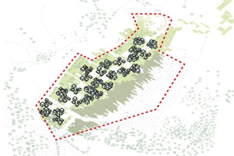
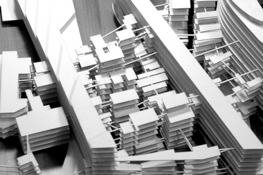
DESCRIPTION OF URBAN INTERVENTIONS - A
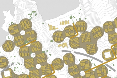
Large open spaces with a trees characterise area A. The area used to be exploited for coal and gravel mining. The new development is built upon this landscape altered by human activity. The development connects to the city in the North and West with a dense settlement pattern. Two thirds of the area will remain un-built and will be used for agriculture, as recreational area, as flood-plain and as reserve for future expansion. The settlement showcases a compact sequence of one to three-story buildings. These buildings form neighborhood clusters. Due to the compact urban pattern energy and waste facilities can be centralised. The circulation happens through lateral streets ending in cul-de-sacs penetrating the settlement. This interface of street and residential space encourages soft mobility in combination with a dense network of pedestrian and bike circulation. The intersection of these circulation networks is dotted with urban furniture. Mutual respect and interaction amongst all inhabitants is literally programmed into the design.
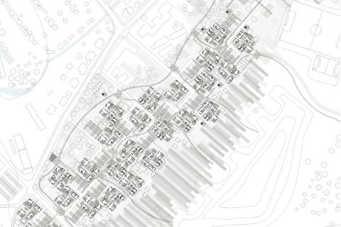
DESCRIPTION OF ARCHITECTURAL INTERVENTIONS - A
Dwelling typologies in area A are modular and features useable floor spaces of 60 to 120 m2. These distribute over 1, 2 or 3 floors. Flat roofs can be used as terraces. Natural ventilation and light is garantied due to the spaced allocation of buildings and different building heights. The floorplans follow a similar modular logic. Circulation and cores structure large open spaces around them. The combination of spatial modules to dwelling units and dwelling units to neighborhood clusters account for a near endless variety of dwelling typologies. These new typologies question the traditional typologies of single family house, semi-detached house and row house. These new typologies form a hybrid of private enclosed space and public outer space. The units can be combined at will due to their small scale modularity. Dwelling units have a direct connection to the outer space that can be used a private garden or as communal open space. The buildings follow are built as Passivhaus.
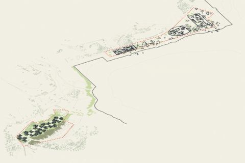
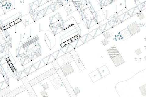
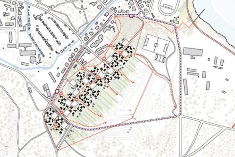
DESCRIPTION OF URBAN INTERVENTIONS - B
The artificially created edge of the river Goitzsche is the characteristic element of area B. As the recent floods showed, the relation between water and city has not been articulated. The “artificiality” of the water edge and the reclaimed land behind form the base of the design strategy. The design acts on two levels: On the street level the landscape is structured by large quads or pixels with a system of access and pathways amongst them. This field deliberately denies hierarchy. These quads or pixels have a variety of functions. While some act as agricultural land others structure the urban space as viewing platform, quiet zones or “re-nature”. Others still are urban furniture and can be move around the water edge like gigantic toys. Present vegetation and buildings are integrated into the pixel-landscape. On a second level a the actual buildings are floating above this landscape as self-standing superstructure. This superstructure offers a maximum of flexibility. In contrast to the mega-structures of the 70s the structure is leight-weight and smart. The structure offers climatised spaces and invisible telecommunication and information technology. These spaces are furnished with moveable room-sized furniture elements. This allows to re-program the structure depending on the actual needs.
DESCRIPTION OF ARCHITECTURAL INTERVENTIONS - B
The architecture within area B is split between two levels. The street-level landscape of pixels and the large suspended structures. Both carry an new kind of modular architecture that attaches onto a supporting structure. On the scale of the landscape the public is invited to program the pixel structure. The public can appropriate these quad elements by programming them with various functions. Within the larger suspended structures appropriation happens as the spaces are defined by moveable room-sized pieces of furniture. The structure provides for climatic control and offers an open plane suspended from the ground, suitable to all needs. Spatial program is subdivided into mobile and non-mobile categories. All domestic functions can be mobile with the exception of water and waste and hence be accommodated within the mobile spatial furniture elements. They can be tailored to the needs of their future residents and upgraded or recycled in the future.
Authors: Aurel von Richthofen
with Alessia Pegorin and Estrella Sanz Alonso
Place: Bitterfeld - Wolfen, Germany
Year: 2013
Size: n / a
Type: Competition
Client: Europan